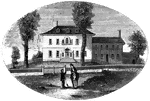
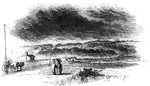
Morristown
Washington's head-quarters at Morristown. This view is from the forks of the road, directly in front…
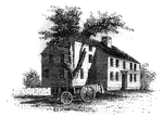
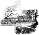
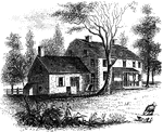
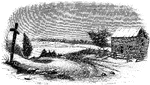
Mrs. Mathews' house
Mrs. Mathews' house. This sketch was made from the left bank of the Rahway, at the site of the old bridge.…
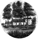
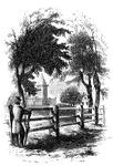
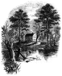
Steuben's Head-Quarters
Steuben's head-quarters. This view is from the field in front of the house, looking north. The dwelling…
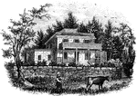
![The Yeoman House. This view is from the road, looking north. An attempt was made by a soldier to burn the house, but so rapid was the march of the invaders that the flames had made but little progress before the troops were far on their road to the village. An [African American] woman, who was concealed under some corn-stalks near, extinguished the flames. The house is about half a mile from the river, on the right side of the road from the landing to Kingston village.](https://etc.usf.edu/clipart/13500/13510/yeoman_13510_mth.gif)
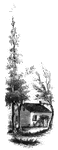
Yeoman House
The Yeoman House. This view is from the road, looking north. An attempt was made by a soldier to burn…
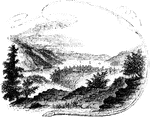
Bennington Battle-ground
The Bennington battle-ground. This view is from the hill on the southwest bank of the Walloomscoick,…
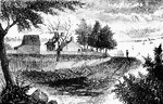
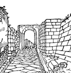
Fitch's Point
Fitch's Point, the landing-place of the British. This view is from the west side of Gregory's Point,…
Milford Hill
West Bridge and Milford Hill. This view is from the Milford Road, eastward of West Bridge. The high…
Barrett's House
"Colonel Barrett's House. This sketch is from the road leading to the village of Concord by the way…
Lexington Monument
"Monument at Lexington. This view is from the Concord Road, looking eastward, and shows a portion of…
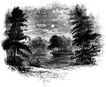
Williams landing-place
"Landing-place of Roger Williams. This view is on the left bank of the Seekonk, looking south. The point…
Prescott's Headquarters
"Prescott's Headquarters. This house is on the east side of the west road, about a mile from the bay.…
Greene and Knox Head-Quarters
"Head-quarters of Greene and Knox. This view is from the turnpike road, looking southeast. The water…

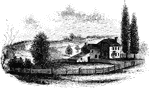
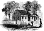
Mrs. Falls'
"Mrs. Falls'. This house, now (1850) owned by Mr. Samuel Moore, is a frame building, and stands on the…
Smith's House
"Smith's House. This view is from the slope in front of the house. The main building is of stone; the…
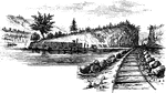
Beverly Dock
"View at Beverly Dock. This view is taken from the Hudson River rail-road, looking north. The dock,…
Fort Montgomery
"View near Fort Montgomery. This view is from an eminence near the mountain road, about three quarters…
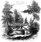
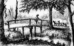
Sleepy Hollow
"Bridge over Sleepy Hollow Creek. Ichabod, according to Irving, in the Legend, returning from…
Ramapo Pass
"Remains of intrenchments the Ramapo Pass. This view is from the road, looking north toward the village…
Hopper House
"The Hopper House. This view is from the road, looking northeast. The low part, on the left, is a portion…
Worth's Mills
"Bridge at Worth's Mill's. This substantial stone bridge, over Stony Brook, is upon the site of the…
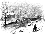
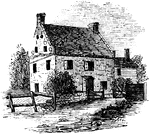
Washington's head-quarters
"Washington's head-quarters. This view is from the Reading rail-road, looking east, and includes a portion…
Battle of Shiloh
"Battle of Shiloh, or Pittsburg Landing, left wing- the woods on fire during the engagement of Sunday,…
Battle of Shiloh
"Battle of Shiloh, or Pittsburg Landing, left wing- the woods on fire during the engagement of Sunday,…
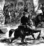
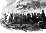
Lick Creek Bottom - Horse and Rider
"Advance of Federal troops on Corinth- the Carnival of Mud- scene at Lick Creek Bottom, between Pittsburg…
Lick Creek Bottom - In the Mud
"Advance of Federal troops on Corinth- the Carnival of Mud- scene at Lick Creek Bottom, between Pittsburg…
Lick Creek Bottom - Marching through the Mud
"Advance of Federal troops on Corinth- the Carnival of Mud- scene at Lick Creek Bottom, between Pittsburg…
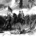
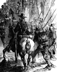
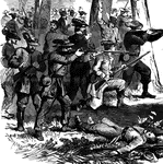
Attack at Harrisonburg
"Gallant attack by 150 of the Pennsylvania Bucktails, led by Colonel Kane, upon a portion of General…
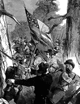
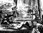
Attack at Harrisonburg
"Gallant attack by 150 of the Pennsylvania Bucktails, led by Colonel Kane, upon a portion of General…
Attack at Harrisonburg
"Gallant attack by 150 of the Pennsylvania Bucktails, led by Colonel Kane, upon a portion of General…
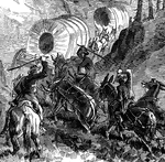
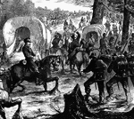
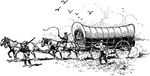
Baggage Train to Falmouth, VA
"Federal baggage train on its way to the army at Falmouth, VA., December, 1862. Our illustration represents…
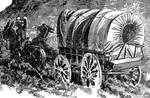
Baggage Train Wagon
"Federal baggage train on its way to the army at Falmouth, VA., December, 1862. Our illustration represents…

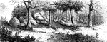
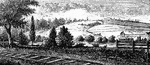
Regulator Battle-ground
"The Regulator battle-ground. This view is from the south side of the Salisbury Road, which is marked…
Trading Ford
"Trading Ford. This view of the Trading Ford, where greene, with Morgan and his light troops, crossed…
Guilford Battle-ground
"View of the battle-ground. This view is from the eminence southwest of the site of old Guilford Court…
Rugeley's
"View at Rugeley's. This view is from the south side of the bridge. The counterfeit cannon was placed…
Gravesend Bay
"View at Gravesend Bay. This view is from the road on the high shore, a little below Fort Hamilton,…
Cortelyou's House
"Cortelyou's House. This house, built of stone, with a brick gable from eaves to peak, is yet (1852)…
Washington's Head-Quarters
"Washington's head-quarters. The house occupied by Washington while the army was at White Plains is…
Chatterton's Hill
"Chatterton's Hill, from the rail-way station. This is a view of the southeastern side of Chatterton's…
Germans
"Early Germans. These German ancestors of ours, for so we must consider them, since the chief element…
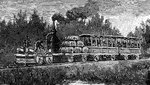
Passenger Train
"The first passenger locomotive built in the United States. A year after the Enterprise sailed for India,…
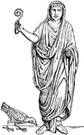
Auger
"Among the anceient Romans, a functionary whose duty it was to observe and to interpret, according to…
Death of Laius
"When grown up, Oedipus is told by the oracle that he would slay his father and marry his mother. On…
Cippus
"A low column, sometimes round, but more frequently rectangular. Cippi were used for various purposes;…
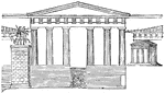
Propylea restored
"A. Pinacotheca, B. Temple of Nike Apteros, C. Pedestal of Agrippa, D. Road leading to the central entrace,…
Pons Cestius
"A bridge. As the rivers of Greece were small, and the use of the arch known to them only to a limited…
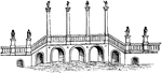
Pons Aelius
"A bridge. As the rivers of Greece were small, and the use of the arch known to them only to a limited…
Pons Ariminum
"A bridge. As the rivers of Greece were small, and the use of the arch known to them only to a limited…
Pons Trajan
"A bridge. As the rivers of Greece were small, and the use of the arch known to them only to a limited…
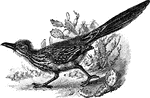
Chaparral
Also called the ground cuckoo, road runner, or paisano. A large errestrial bird or the family Cuculidæ.
Roman augur
"Represents a Roman augur, with his litmus or divining staff, observing the signs in the heavens." —…
Via
"Via, a public road. It was not until the period of the long protracted Samnite wars that the necessity…
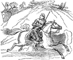
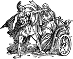
Escape of Charles II
"That prince escaped from the battle of Worcester as soon as he saw that the day was lost. With a small…
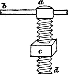
Screw
"The screw may be considered as a winding wedge; for it has the same relation to a straight wedge that…

Road Oiler
This illustration shows a machine used to put oil on roads during its construction, in the nineteenth…
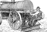
Road Oiler
This illustration shows a machine used to put oil on roads during its construction, in the nineteenth…
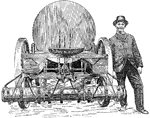
Road Oiler
This illustration shows a machine used to put oil on roads during its construction, in the nineteenth…